I started from Bangalore towards Ooty Via Mysore at about 8:30AM on a sunday in April Month which is peak summer time in India. This is bad time of the day to start from Bangalore because of heavy traffic movement towards during weekend. Ideal time to start from Bangalore towards Mysore especially if you have to go past Mysore to places like Nanjangud, Chamarajnagar, Gundlupet, Ooty, Madikeri etc is by 5AM, unless, you have enough patience to sit in the vehicle for almost 4hrs just to commute between Bangalore and Mysore. By the time I reached Mysore it was already 12PM and I still had to drive 160kms to reach Ooty and I really wanted to reach there by afternoon but for the delayed start I could reach there only by 4PM.
On my way to ooty I took the route Bangalore - Kengeri - bidadi - Ramnagar - Channapatna - Maddur - Mandya - Srirangapatna - Mysore (Outer Ring Road by pass) - Nanjangud - Gundlupet - Theppakadu - Masingudi - Ooty (Total of 290kms).
It was very hot and humid until we crossed Masingudi and started climbing the narrow Ghat Section towards Ooty. Oh! what a drive it was. Really challenging and awesome and my new Ritz VDi never let me down and it was a very comfortable drive. We were half way through the Ghats climbing the hill and all of a sudden the temperature cooled down and the whether was very pleasant. The stretch within Bandipur in Karnataka and Theppakadu (Masingudi) in Tamilnadu has road humps every 1/2 kilometre. I was lucky to locate heard of Wild Elephants, Deer, 3bisons, a Peacock and lots of Monkeys of different breeds. Bandipur and Mudumalai are reserved forests in Karnataka and Tamilnadu respectively. Stopping Vehicles and feeding wild animals is strictly prohibited. Most importantly, please do not litter the place (Avoid plastics).
Road Condition between Theppakadu to the base of the hill from where we climb to Ooty Via Masingudi is not all that great. This stretch is about 18kms from Theppakadu junction. However, the road condition is good as you start climbing up the hill through the hairpin curves but the road is good enough only for one vehicle to pass. So please give way for vehicles moving up hill. Those driving down this hill need to be extremely careful as the road is too steep to easily handle.
Some places to visit while at Ooty - Botanical Garden, Rose Garden, Dodda Betta, Boating at Ooty Lake (Not all that Great), Boat ride at Pykara Boat Club, Mukurthi National Park, Kamaraj Dam,, Ooty Golf Course, Emerald Lake etc. Ride on the toy train from Ooty to Coonor is really wonderful.
Further ahead, some interesting sight seeing places at Coonoor is Sims Park, Dolphins Nose, Catherine Falls, Hidden Valley, Lambs Rock, Wellington Golf Course etc.
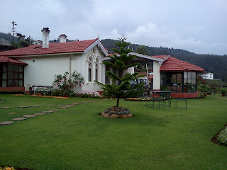
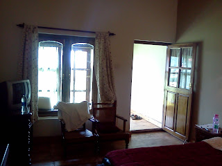
I got an opportunity to stay at the "Sherlock" resort. Its a beautiful place to stay and is a very high elevation which makes it possible to get a mesmarising view of the Ooty - Coonoor Valley. Has lot of open space with lawn in front of every room. Each and every room has been very neatly decorated including fire place. The restaurant in the resort offers variety of food, both Veg and Non-Veg.


On my way to ooty I took the route Bangalore - Kengeri - bidadi - Ramnagar - Channapatna - Maddur - Mandya - Srirangapatna - Mysore (Outer Ring Road by pass) - Nanjangud - Gundlupet - Theppakadu - Masingudi - Ooty (Total of 290kms).
It was very hot and humid until we crossed Masingudi and started climbing the narrow Ghat Section towards Ooty. Oh! what a drive it was. Really challenging and awesome and my new Ritz VDi never let me down and it was a very comfortable drive. We were half way through the Ghats climbing the hill and all of a sudden the temperature cooled down and the whether was very pleasant. The stretch within Bandipur in Karnataka and Theppakadu (Masingudi) in Tamilnadu has road humps every 1/2 kilometre. I was lucky to locate heard of Wild Elephants, Deer, 3bisons, a Peacock and lots of Monkeys of different breeds. Bandipur and Mudumalai are reserved forests in Karnataka and Tamilnadu respectively. Stopping Vehicles and feeding wild animals is strictly prohibited. Most importantly, please do not litter the place (Avoid plastics).
Road Condition between Theppakadu to the base of the hill from where we climb to Ooty Via Masingudi is not all that great. This stretch is about 18kms from Theppakadu junction. However, the road condition is good as you start climbing up the hill through the hairpin curves but the road is good enough only for one vehicle to pass. So please give way for vehicles moving up hill. Those driving down this hill need to be extremely careful as the road is too steep to easily handle.
Some places to visit while at Ooty - Botanical Garden, Rose Garden, Dodda Betta, Boating at Ooty Lake (Not all that Great), Boat ride at Pykara Boat Club, Mukurthi National Park, Kamaraj Dam,, Ooty Golf Course, Emerald Lake etc. Ride on the toy train from Ooty to Coonor is really wonderful.
Further ahead, some interesting sight seeing places at Coonoor is Sims Park, Dolphins Nose, Catherine Falls, Hidden Valley, Lambs Rock, Wellington Golf Course etc.
I got an opportunity to stay at the "Sherlock" resort. Its a beautiful place to stay and is a very high elevation which makes it possible to get a mesmarising view of the Ooty - Coonoor Valley. Has lot of open space with lawn in front of every room. Each and every room has been very neatly decorated including fire place. The restaurant in the resort offers variety of food, both Veg and Non-Veg.


On my way back from Ooty I reached Gundlupet Via Gudlur and Theppakadu. It is longer route but I did not want to take the risk of driving downhill from Ooty to Masinagudi. Road was not all that great but motorable with ease. From Gundlupet I reached Chamarajnagar. This is 33km drive and the road has been done with lot of patch work which earlier had potholes. Not much of traffic and one can drive at an average speed of 60km/ph.
I then Drove back to Bangalore from Chamarajnagar Via Sanhaemarahalli, Yelandur, Kollegal, Malavalli, Halagur Cross, Sathnur Cross, Kanakapura, Talagttapura, Nice Road Clover Reef Junction, BangaloreSouth. Road is excellent condition for it is the national highway No 209 which connects Bangalore to Dindigul Via Kanakapura, Kollegal, Chamarajnagar, Satyamangala, Coimbatore, Pollachi, udumalaipetti and Palani covering approximately 440Kms covering important town and cities of Karnataka and Tamilnadu.